 1200 Hrs 9th - high pressure ridging north, giving a brisk W'ly but of southerly origins
Mild, changeable and much wetter than average - very few frosts, yet snow on the 22nd gave a 3cm cover to equal the latest date on which a 'Day of Laying Snow' has been recorded at this site.
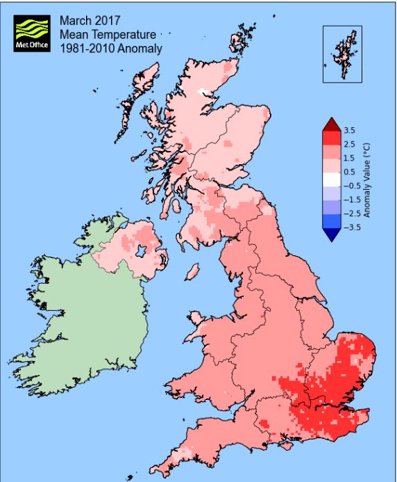
March continued the awfully mild start to the year and was significantly warmer than average, especially so by night and thus frosts were quite rare. Whilst rainfall was frequent it was never that heavy (albeit at times it did fall heavily in the Lake District), but the month ended with the total well above average.
It was very much another South Westerly month and whilst the month started cool(ish), mild conditions soon prevailed, with a brief lull 20th-22nd. There was a gloriously sunny period during 23rd-27th before the month closed on an unsettled note.
MSLP of 1011.2 Mb was -1.5 Mb below the local average for March with low pressure tending to be in the ascendency, with high pressure limited to a few brief spells, most notably during the 23rd-27th.
Overall a mean minimum of 3.62°c and a mean maximum of 10.96°c saw the temperature 1.9°c above the 1981-2010 average and it was the warmest since 2012. The highest maximum temperature recorded was 15.9°c (26th), the lowest minimum -2.1°c (25th).
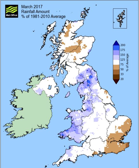
Rainfall of 100.2 mm (Crosby Ravensworth School 111.2 mm - Castlehowe Scar 129.4 mm - Reagill 96.8 mm) made it the wettest March since 2015 (the 3rd wettest of the 10 recorded) and was 137.1% of average for 2008-16.
Locally, rainfall percentages were also well above average. They ranged from a low of 127.8% at Kirkby Thore, but which were much higher within the Lake District, 147.9% at Brothers Water was high, but 181% at Seathwaite was greater still and which recorded 235.6 mm in just three days (17-19th) with 109.0 mm falling on the 17th.
At the Met' Office site at Newton Rigg, 123.2 mm (162.5%) made it the wettest March since 1994 and in a series back to 1900 there have been 108 drier and 8 wetter (with 1 year of missing data). In a series back to 1914 a mean temperature of 6.8°c is the warmest since 2012 with 89 having been colder, 8 warmer and 1 having the same mean temperature (5 yrs of missing data).
Figures from the Environment Agency’s rainfall sites were, (figure in brackets being the monthly average for 1961-90) ‘Data kindly provided by the Hydrometry and Telemetry team of the Environment Agency (Penrith)’:
Kirkby Thore 70.4 mm (55.1 mm)
Haresceugh Castle (Kirkoswald) 108.33 mm (84.6 mm)
Brothers Water 324.03 mm (219 mm) and
577.4 mm at Seathwaite Farm (Borrowdale - 319 mm [average for 1981-2010])
1st - 6th Low pressure (LP) systems surrounded the UK at the beginning of the month, although the mainland itself was sat within a slack pressure gradient, but with fronts always nearby, the weather tended to be mixed in nature. Sun and the odd shower on the 1st was repeated with a bit more cloud on the 2nd and temperatures for the first three days were pegged just below 8°c, but only the 1st saw a frost.
LP to our south pushed fronts north over the UK on the 3rd and brought a spell of rain (8.7 mm) from 2 p.m. onwards that lasted throughout the evening. That LP system trundled north and on the 4th was centred over Eire and yet even with fronts spiralling from off that low, the day was reasonable and suddenly much milder at 11.9°c. Rain did arrive in the evening, but only gave 4.0 mm and the 5th was another reasonable day with some sunny intervals.
The LP of the previous days had broadened out before moving north and being replaced by another system from the south, but somehow we stayed dry on the 6th with more sunny intervals.
7th - 10th At the start of the period a slack pressure gradient gave a couple of quiet days, although fronts moving north overnight 7-8th brought some rain, but with both days having some sunny spells. The 7th started with a slight frost and plenty of sun before clouding over ahead of those fronts, but with afternoon sunshine on the 8th the temperature rose to 12.4°c.
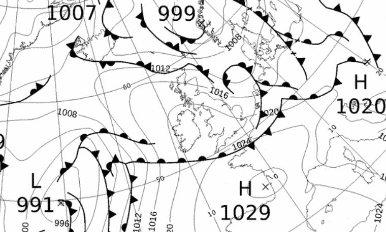
High pressure (HP) in Biscay then ridged north over the UK for the 9-10th bringing a S'ly airflow, although the positioning of that HP saw the 9th under a W'ly flow. The 9th was gorgeous with wall to wall sun, the temperature cooled slightly due to the W'ly flow, but it was still mild at 10.7°c. However, the 10th saw a warm front gradually move north and this saw early cloud been replaced by murky conditions with a steady drizzle.
1200 Hrs 9th - high pressure ridging north, giving a brisk W'ly but of southerly origins
11th - 15th The general theme became a mixed, but mild one, with LP more frequent, although without ever becoming fully dominant as HP over Europe or Biscay occasionally tried to ridge back over the UK.
The HP of the previous days was shunted away into Europe where it remained dominant, but now frontal systems more freely visited the UK, however, rainfall totals still remained low.
The 11th was a grey, murky day and started as a 'day of fog' with that murk and drizzle severely reducing the visibility. The Azores HP tried to ridge in 12-13th and this gave a couple of bright and breezy days, with the temperature rising to 13.2°c (13th) with a little sunshine and a brisk SSW'ly flow.
The wind increased in strength over the coming days as the LP to the north and HP to the south created a slight squeeze on the pressure gradient and apart from the noticeable wind it remained terribly mild with the constant feed of SSW'ly's keeping the temperature over 12°c.
The HP was most dominant on the 15th which was sunny and breezy throughout, but after brief resistance the HP would now give way.
16th - 19th The period remained very mild, both by day and night and plagued by frequent drizzle as LP became more dominant.
Cold fronts associated to LP south of Greenland were slow to travel across the UK on the 16th which was a windy day with frequent drizzle. A number of LP systems were sat out in the Atlantic and these would push fronts across the UK in the coming days, but still rainfall totals remained low as those fronts only brought spells of light rain and drizzle, typically 2.5 mm each day.
The 19th saw LP east of Iceland with fronts trailing off that steadily moved south across the UK giving another drizzly day, but which ultimately would herald the start of a cooler spell.
20th - 22nd The cold fronts from the 19th finally cleared south during the morning of the 20th and by the afternoon we were enjoying some sunshine, however, at 1530 hrs there was a heavy hail shower that lasted for 10 minutes. This was courtesy of trough lines circulating in a brisk W'ly flow and which would give some rain later in the evening and a little hail overnight into the 21st.
Now the airflow was of Arctic origins brought on an unstable W'ly flow and the 21st saw numerous showers of hail, sleet and rain with sunny spells inbetween, but temperatures now dipped, on the 21st down to 6.6°c.
LP then developed to our south and was positioned in the Eire Sea overnight 21st - 22nd and which pushed a frontal system north. As those fronts met the colder air over the northern half of the UK the rain on those fronts turned to snow, but altitude was crucial as to whether you got snow or rain.
Here at Maulds Meaburn we had snow, albeit, quite wet. At 0600 hrs it lay 4cms deep, but after 0730 hrs the snowfall turned back to rain and by 0900 hrs the depth was down to 3cms and would soon all melt away.
However, at Kings Meaburn at 0600 hrs, there was practically no snow at all and certainly none on the north side of the village. That snow with the showers of the previous day saw 15.4 mm credited back to the 21st with the rain on the 22nd totalling 9.9 mm.
It had been a cold snap without a frost, the 22nd only dropped as low as 0.5°c, albeit it did have a 'day of laying snow' (which equals the latest date at this site to record such) and the 5.3°c (41.5°f) also on the 22nd was the month's coldest day.
23rd - 28th And from a slight wintry feel, we headed straight into spring.
HP in Biscay started to ridge towards the UK on the 23rd, elongating W-E over the UK 24th and then becoming dominant through the rest of the period. This brought dry and settled conditions, temperatures over 15°c after cool starts to the day, but the main feature was the amount of sun which was virtually wall to wall.
And to make it even better, it coincided with a weekend. However, an ESE'ly breeze meant that in the sun and out of the wind it was lovely, but in the shade and wind, it still felt a little cool.
The 23rd was a transitional day with the cloud clearing to sun in the afternoon and after a cool start with a touch of frost, the 24th was glorious, with barely a cloud in the sky. Whilst the 24th would only attain 13.8°c, both the 25th and 26th went higher, 15.8°c on the 25th just pipped by 15.9°c (60.6°f) on the 26th which would be the month's warmest day.
The 25th with those clear skies had seen the temperature drop to a month's low of -2.1°c (28.2°f) and ground frosts were recorded every day during the 21st - 28th, although both the 26+27th just avoided air frosts. The 27th was again a lovely sunny day to start the working week, but a steady E-ESE'ly breeze created a noticeable chill in the air. The spell of fine weather just lasted into the 28th, which with clear, but misty skies overnight 27-28th, started with the slightest of air frosts, -0.1°c. The day was decent enough with plenty of sunshine, before clouding over in the afternoon, this marking the change to unsettled conditions as LP in the mid Atlantic would now start to push a series of rain bearing fronts over the UK.
29th - 31st LP would then dominate at the end of the month; several areas of LP were sat out in the Atlantic and these would push fronts towards the UK. The occluded front from late on the 28th was replaced by another occlusion moving up from the south and with a cold front attached that lay S-N through Eire. Murky until 1500 hrs when the rain started and which would last, virtually without a break, into the 31st and which was heavy for awhile during the evening of the 30th.
This gave 12.9 mm on the 29th and a further 15.8 mm on the 30th, the month's wettest day. The winds were feeding in mild air of southerly origins and subsequently it turned mild, especially at night with the cloudy skies.
The 30th with that rain was mild as opposed to warm, but a minimum temperature of 10.2°c (50.4°f) is crazily high and now the highest March minimum recorded at this site (by comparison I have not yet recorded a minimum temperature over 10°c in April!).
The 31st almost repeated the fete at 9.9°c with early gusty showers dying out as those fronts now cleared through.
Rainfall totalled 100.2 mm for the month, with rain recorded on 21 days of which 17 were 'Wet days' (1.0mm +).
The Mean Temperature for the month was 7.29°c -- The Mean Max' was 10.96°c -- The Mean Min' 3.62°c.
We had 5 Air Frosts in the month (year 25) -- Grass frosts totalled 15 (year 48).
The 1 foot soil temp ranged from a low of 5.1°c on the 1st to a high of 9.0°c on the 31st -- with a monthly mean of 6.8°c
The 1 meter soil temp ranged from a low of 6.4°c on the 4-6th to a high of 7.6°c on the 22nd -- with a monthly mean of 7.0°c
COMPARISONS:-
* March 2017 rainfall was 137.1% of the March average for 2008 - 2016
* March 2017 was 2.08°c warmer than the March average for 2009 - 2016 and 1.9°c warmer than the local long term average 1981-2010
JANUARY 2010
FEBRUARY 2010
MARCH 2010
APRIL 2010
MAY 2010
JUNE 2010
JULY 2010
AUGUST 2010
SEPTEMBER 2010
OCTOBER 2010
NOVEMBER 2010
DECEMBER 2010
JANUARY 2011
FEBRUARY 2011
MARCH 2011
APRIL 2011
MAY 2011
JUNE 2011
JULY 2011
AUGUST 2011
SEPTEMBER 2011
OCTOBER 2011
NOVEMBER 2011
DECEMBER 2011
JANUARY 2012
FEBRUARY 2012
MARCH 2012
APRIL 2012
MAY 2012
JUNE 2012
JULY 2012
AUGUST 2012
SEPTEMBER 2012
OCTOBER 2012
NOVEMBER 2012
DECEMBER 2012
SUMMER 2012
REVIEW OF 2012
JANUARY 2013
FEBRUARY 2013
MARCH 2013
APRIL 2013
MAY 2013
JUNE 2013
JULY 2013
AUGUST 2013
SEPTEMBER 2013
OCTOBER 2013
NOVEMBER 2013
DECEMBER 2013
REVIEW OF 2013
JANUARY 2014
FEBRUARY 2014
MARCH 2014
APRIL 2014
MAY 2014
JUNE 2014
JULY 2014
AUGUST 2014
SEPTEMBER 2014
OCTOBER 2014
NOVEMBER 2014
DECEMBER 2014
WINTER 2014
REVIEW OF 2014
JANUARY 2015
FEBRUARY 2015
MARCH 2015
APRIL 2015
MAY 2015
JUNE 2015
JULY 2015
AUGUST 2015
SEPTEMBER 2015
OCTOBER 2015
NOVEMBER 2015
DECEMBER 2015
REVIEW OF 2015
JANUARY 2016
FEBRUARY 2016
MARCH 2016
APRIL 2016
MAY 2016
JUNE 2016
JULY 2016
AUGUST 2016
SEPTEMBER 2016
OCTOBER 2016
NOVEMBER 2016
DECEMBER 2016
REVIEW OF 2016
OTHER ARTICLES
The Oldest Inhabitant
An Inch Of Scotch Mist
© Darren Rogers 2010-16
Want to comment on this site? email